Plate Boundaries Divergent Convergent Transform
- Published August 3, 2025
Earths lithospheric plates interact at boundaries where their movement shapes the planets surface through processes like rifting subduction and faulting. These interactions create geological features such as basins mountains and faults which are critical for hydrocarbon exploration. Understanding divergent convergent and transform boundaries allows geologists to identify sedimentary basins and traps where oil and gas accumulate.
Divergent Boundaries
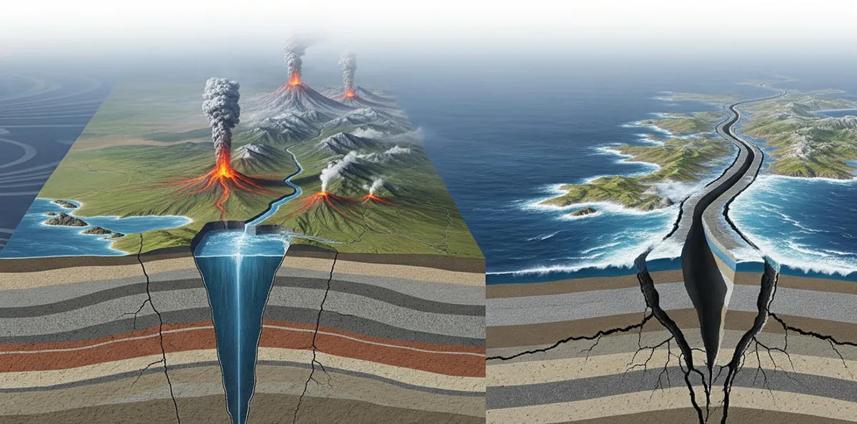
At divergent boundaries plates move apart driven by mantle upwelling. This process thins the crust creating rift valleys on continents or mid-ocean ridges in oceans. New crust forms as magma rises and solidifies often basalt in oceanic settings. These regions accumulate thick sedimentary sequences as the crust subsides making them prime targets for hydrocarbon exploration. For instance the East African Rift a continental divergent boundary has formed basins like the Albertine Basin in Uganda where recent oil discoveries highlight its potential. The stretching of the crust and sedimentation create ideal conditions for reservoir rocks while organic-rich sediments deposited in these basins can mature into source rocks.
Convergent Boundaries
When plates collide at convergent boundaries one plate often subducts beneath another or both plates crumple to form mountain ranges. Subduction occurs when denser oceanic crust sinks into the mantle forming deep ocean trenches and volcanic arcs. Alternatively continental collisions create fold-thrust belts and foreland basins as the crust buckles under compression. These basins trap thick sediment layers including organic-rich shales that can serve as source rocks. Foreland basins are particularly significant for petroleum geology due to their ability to accumulate hydrocarbons. The Andean foreland basins in South America such as the Llanos Basin in Colombia exemplify this with substantial oil reserves formed by sediment deposition adjacent to the Andes mountain range created during plate convergence.
Transform Boundaries
Transform boundaries involve plates sliding past each other horizontally along strike-slip faults. This lateral movement generates earthquakes but does not typically create or destroy crust. The resulting fault systems can influence basin geometry or create localized structural traps for hydrocarbons. While transform boundaries produce fewer basins than divergent or convergent settings their faults can act as migration pathways or seals for oil and gas. The San Andreas Fault in California a well-known transform boundary affects nearby basins like the Los Angeles Basin where faulting has shaped reservoir configurations and trap formation.
Table 1 Boundary Types and Geological Features
| Boundary Type | Key Process | Geological Features | Petroleum Relevance |
|---|---|---|---|
| Divergent | Plates move apart | Rift valleys mid-ocean ridges | Forms rift basins with reservoirs |
| Convergent | Plates collide subduction | Trenches fold-thrust belts | Creates foreland basins source rocks |
| Transform | Plates slide past each other | Strike-slip faults | Influences traps basin geometry |
Role in Basin Formation
The processes at plate boundaries directly influence the formation of sedimentary basins critical for hydrocarbons. Divergent boundaries create rift basins through crustal extension filling with sediments that form reservoirs and source rocks. Convergent boundaries produce foreland basins where sediment accumulation and tectonic compression trap hydrocarbons as seen in the Zagros Basin in Iran. Transform boundaries modify basin geometry or create structural traps through faulting as observed in the Ventura Basin near the San Andreas Fault. These basins vary in sediment thickness burial history and thermal maturation all of which geologists analyze to assess hydrocarbon potential.
Exploration Strategies
Geologists leverage plate boundary knowledge to guide exploration. Seismic imaging maps basin structures and faults identifying potential traps. Basin analysis evaluates sediment thickness and source rock quality particularly in rift and foreland basins. Assessing tectonic stability helps avoid drilling hazards like fault reactivation which could lead to operational issues such as wellbore collapse. For example in the North Sea rift basins formed by divergent tectonics during the Mesozoic geologists used seismic data to target Jurassic source rocks and Cretaceous reservoirs resulting in discoveries like the Ekofisk field.
Future Trends
Advancements in technology enhance exploration at plate boundaries. High-resolution 3D seismic imaging improves the mapping of complex fault systems and basin structures. Geodynamic models simulate plate interactions to predict basin evolution over time. Machine learning algorithms analyze large datasets from seismic surveys and well logs to identify prospective hydrocarbon traps with greater accuracy. These tools are transforming exploration in regions like the East African Rift where emerging basins are being evaluated for oil and gas potential.
Table 2 Exploration Applications by Boundary Type
| Boundary Type | Exploration Focus | Example Basin | Technology Used |
|---|---|---|---|
| Divergent | Rift basins thick sediments | North Sea | 3D seismic geodynamic models |
| Convergent | Foreland basins source rocks | Zagros Basin | Seismic imaging well logs |
| Transform | Structural traps | Los Angeles Basin | Fault mapping machine learning |
Summary
Divergent convergent and transform plate boundaries drive geological processes that form sedimentary basins and traps essential for hydrocarbon exploration. Rifting creates sediment-rich basins subduction forms foreland basins with source rocks and faulting at transform boundaries shapes traps. Advanced technologies like seismic imaging and machine learning enhance the ability to target these basins effectively.
Cuestionario
-
Which process is associated with divergent boundaries?
a) Subduction
b) Crustal extension and rifting
c) Lateral faulting
Correct Answer b) Crustal extension and rifting -
What type of basin is typically formed at convergent boundaries?
a) Rift basin
b) Foreland basin
c) Strike-slip basin
Correct Answer b) Foreland basin -
How do transform boundaries contribute to hydrocarbon exploration?
a) Create thick sedimentary sequences
b) Form structural traps through faulting
c) Drive source rock maturation
Correct Answer b) Form structural traps through faulting
Bibliography
Sources Used
- Selley R C & Sonnenberg S A (2014) Elements of Petroleum Geology (3rd ed) Academic Press
Explains plate boundaries and their impact on basin formation - USGS (2020) Plate Tectonics and Sedimentary Basins Available at https://www.usgs.gov/energy-and-minerals/energy-resources-program
Details tectonic processes and basin types - AAPG Memoir 60 (1994) The Petroleum System From Source to Trap American Association of Petroleum Geologists
Connects plate boundaries to hydrocarbon systems
Recommended Reading
- Hyne N J (2012) Nontechnical Guide to Petroleum Geology Exploration Drilling & Production PennWell Books
Accessible overview of tectonics and basins Available at https://www.pennwellbooks.com/nontechnical-guide-to-petroleum-geology-exploration-drilling-production/ - Condie K C (2015) Plate Tectonics & Crustal Evolution Elsevier
In-depth analysis of plate boundary processes
Direct Links
- AAPG Educational Resources Webinars and articles on tectonics and petroleum geology
- USGS Plate Tectonics Information on plate boundaries and basins
- SPE Technical Resources Insights on tectonics in oil and gas exploration